For most people the navigation question has only ever had two real answers: Google Maps or Apple Maps. One ships on practically every Android phone and runs everywhere else too; the other is built into every iPhone. Both are free, both are mature, and in 2026 both are genuinely good at the thing they were made for, which is driving a car from A to B. This is a fair, current look at how they actually compare, and then an honest note about who they still do not serve.
I should be upfront: I ride a scooter and I build Urban Rider, a navigation app for two-wheelers, which I come to at the end. So read the comparison itself as straight, and the conclusion as the view of someone who lives with the gap these apps leave.
Map data, accuracy and coverage
This is where the two apps are furthest apart. Google Maps has spent two decades building the largest map of the world, with more than 200 million business listings and an enormous pool of crowd-sourced corrections. In rural areas, in smaller towns and outside North America and Western Europe, it is still the more reliable of the two. Apple Maps has improved dramatically since its rocky 2012 launch and rebuilt its map from its own data, and in well mapped cities it is now close to Google on routing accuracy, with voice guidance many people find clearer. The honest summary in 2026: for everyday driving in a major city the two often suggest the same route with similar arrival times, but the moment you leave the dense map, Google Maps pulls ahead on coverage and depth of detail.
Real-time traffic and rerouting
Both pull live traffic and reroute around jams. Google Maps has the larger live signal, drawing on a vast base of active users and incident reports, which tends to give it an edge in heavy, congested cities. Apple Maps gathers traffic and incident data too, increasingly from its own users, and adds neat touches such as weather-aware rerouting. In practice the difference for a typical commute is small; in a notoriously gridlocked city, Google Maps is still the one I would trust to find the gap.
Offline maps
This is a meaningful, often overlooked split. Google Maps lets you download a region and then calculate driving, walking and cycling routes entirely offline, because the routing engine and local detail come down with the map. Apple Maps added offline maps more recently and supports offline turn-by-turn driving, but its offline regions lean more on stored map tiles, and features such as public-transport routing still expect a connection. If you travel where data is patchy or expensive, Google Maps remains the stronger offline tool.
Public transit
For buses, trains and metros, Google Maps generally offers wider coverage, richer schedule layers and more disruption alerts across more cities worldwide. Apple Maps transit has grown city by city and is polished where it exists, with clean line diagrams and clear departure boards, but its coverage map is smaller. If you rely heavily on public transport, especially while travelling, Google Maps is the safer default.
Lane guidance, Live View and the redesigned Apple Maps
Both apps now show detailed lane guidance and 3D building views at complex junctions. Google Maps offers Live View, an augmented-reality walking mode that overlays arrows on the camera feed, plus Immersive View for previewing a route, and through 2025 it began folding in Gemini AI so you can ask questions on the move. Apple Maps counters with Look Around, its street-level imagery, and in iOS 26 a redesigned interface in Apple's Liquid Glass style, along with new features such as Visited Places, a private record of where you have been, and smarter route suggestions based on your habits. Both are clearly investing; the flashier additions land on a phone screen and matter less to a rider who just needs the next turn.
Car integration: CarPlay and Android Auto
Here each app plays to its home turf. Apple Maps is built into CarPlay and benefits from the iOS 26 redesign on the dashboard, and Apple's next-generation CarPlay Ultra is beginning to appear in select cars. Google Maps runs on both Android Auto and CarPlay, so iPhone owners can still choose it in the car, which Android Auto users cannot do in reverse with Apple Maps. If you are inside Apple's ecosystem, Apple Maps feels the most native; if you want one app that works across both car systems, Google Maps is the more flexible pick.
Privacy
This is Apple's clearest advantage. Apple Maps is designed to process much of its data on the device, uses rotating random identifiers rather than your account, and does not associate your searches and navigation with your Apple ID; newer features such as Visited Places are end-to-end encrypted so even Apple cannot read them. Google Maps can offer more personalised results precisely because it links location history, searches and saved places to your Google account, and while you can turn personalisation and Location History off in settings, the default posture collects more. If privacy is a priority, Apple Maps is the stronger choice.
Platform availability
A simple but decisive point. Google Maps runs on Android, iOS and the web, so it follows you across devices and platforms. Apple Maps is exclusive to Apple hardware, the iPhone, iPad, Mac, Apple Watch and CarPlay, with only a limited web version and no Android app at all. If you or the people you share routes with are not all on Apple devices, that alone often settles the choice.
Side-by-side comparison
| Feature | Google Maps | Apple Maps |
|---|---|---|
| Map data and coverage | Largest global coverage, 200M+ business listings, strong rural and international detail | Strong in major cities, thinner outside North America and Western Europe |
| Accuracy | Class-leading, especially in busy and unfamiliar areas | Much improved, close in well mapped cities, clear voice guidance |
| Real-time traffic | Largest live signal, best in heavy congestion | Good, with weather-aware rerouting |
| Offline maps | Full offline routing for driving, walking and cycling | Offline driving turn-by-turn, more limited offline scope |
| Public transit | Wider coverage and richer schedules | Polished where available, smaller coverage |
| Car integration | CarPlay and Android Auto | CarPlay only, deep iPhone integration, CarPlay Ultra rolling out |
| Privacy | Account-linked, personalisation can be turned off | On-device focus, not tied to Apple ID, end-to-end encrypted history |
| Platforms | Android, iOS, web | Apple devices only, no Android app |
| Scooter and moped support | Two-wheeler mode in parts of Asia only, routes like a car elsewhere | No moped or motorcycle profile |
The honest verdict for everyday and car use
Neither app is perfect, and the right answer depends on you.
- Choose Google Maps if you want the most complete map, the best coverage outside big cities, the strongest offline and transit support, and one app that works on any phone and in any car system.
- Choose Apple Maps if you live in Apple's ecosystem, value a clean redesigned interface and tight CarPlay integration, and want the stronger privacy stance, accepting that its coverage thins out away from well mapped areas.
- For most everyday car driving in a major city, you genuinely cannot go far wrong with either. Google Maps is the more capable all-rounder; Apple Maps is the more private and the more seamless on an iPhone.
Where both apps fall short: two-wheelers
Here is the part the spec sheets gloss over. Both Google Maps and Apple Maps are, at their core, car navigators. That is fine in a car. It is a real problem on a scooter, moped or e-bike.
Ask either app for directions on a 50cc scooter in a European or North American city and it will route you exactly as if you were driving a car, motorways and trunk roads included, even though your machine may not legally be allowed on them. Google Maps does have a dedicated two-wheeler mode, but only in parts of Asia, Africa and Latin America, and even there it optimises for motorcycle speed and shortcuts rather than enforcing vehicle-class rules. Apple Maps has no moped or motorcycle profile at all. Neither app understands vehicle class, neither times a trip at the 25 to 50 km/h a small vehicle actually travels, and neither keeps you off the roads a light two-wheeler must avoid. For background on why that matters, see our guide to urban navigation and our micromobility guide.
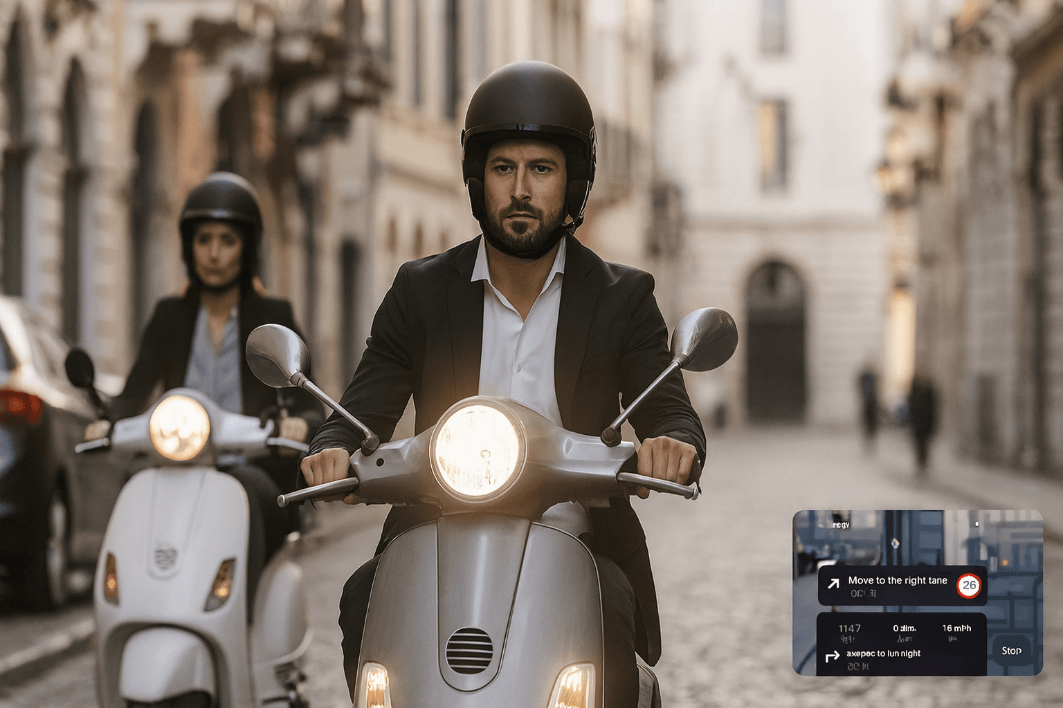
Where Urban Rider fits
This is the app I make, so weigh that accordingly. Urban Rider exists precisely because the mainstream apps treat two wheels as an afterthought. It starts from your vehicle: choose a scooter or moped profile and it avoids highways, major trunk roads and many tunnels by default, because in most countries those machines are not allowed there; choose the motorcycle profile and the faster roads return. Arrival times are modelled on real two-wheel speeds, not the average car on the same road. On the move, Minimal Mode reduces the screen to the next instruction, the distance and your speed, the only things you should read at a glance on a handlebar mount, and your next turn also appears on Apple Watch so the phone can stay clamped to the bars. It is free and asks for no account.
The honest caveats: it is younger and far smaller than either giant, and it is iOS-first, with an Android version in open beta. It does not try to replace Google Maps or Apple Maps in your car. It is built for the trip those apps were never designed for. If you want a wider rundown of the options, including motorcycle touring apps, read our roundup of the best scooter and moped navigation apps.
Frequently asked questions
Is Google Maps or Apple Maps better in 2026?
It depends on what you value. Google Maps wins on global coverage, the depth of its business and transit data and offline routing that still calculates routes without a signal, so it is the safer choice for travel and unfamiliar places. Apple Maps wins on a clean redesigned interface, tight iPhone and CarPlay integration and a stronger privacy stance, since it processes much of its data on the device and does not tie your searches to your Apple ID. For everyday driving in a well mapped city the two are close. Google Maps is the more capable all-rounder, while Apple Maps is the better fit for privacy-conscious iPhone owners.
Does Apple Maps work on Android?
No. Apple Maps is exclusive to Apple devices such as the iPhone, iPad, Mac, Apple Watch and CarPlay. There is no Android app and only a limited web version. Google Maps, by contrast, runs on Android, iOS and the web, which is one reason it remains the default for most people who switch phones or share routes across platforms.
Does Google Maps or Apple Maps work for scooters and mopeds?
Not really. In Europe, North America and Australia both apps route a two-wheeler exactly like a car. Google Maps has a dedicated two-wheeler mode in parts of Asia, Africa and Latin America, but it tunes for motorcycle speed rather than enforcing the roads a moped is legally allowed to use. Apple Maps has no moped or motorcycle profile at all. Neither understands vehicle class, low city speeds or the roads a small vehicle must avoid, which is why a purpose-built rider app like Urban Rider is a better fit for daily two-wheel use.
Which app is more accurate, Google Maps or Apple Maps?
In 2026 the two are close for driving in well mapped cities and often suggest the same route with similar arrival times. Google Maps still leads on raw accuracy thanks to its far larger pool of business listings and crowd-sourced traffic data, and it is the safer choice in rural areas and outside North America and Western Europe. Apple Maps has improved sharply and many riders find its voice guidance clearer, but its data still thins out in less mapped regions.
What is the best navigation alternative for two-wheelers?
For scooters, mopeds and e-bikes the best alternative to the mainstream car apps is one built for the vehicle. Urban Rider is vehicle aware, avoids highways, trunk roads and many tunnels by default on its scooter and moped profiles, times the trip at real two-wheel speeds and strips the screen to one instruction with Minimal Mode. It is free and needs no account. It is iOS-first today with an Android version in open beta.